Although the Romans had settlements nearby, it was the Anglo-Saxons who later settled in the area around 600AD and gave Carlton its name. Coerl is the Anglo-Saxon word for a freeman, while ‘ton’ or ‘tun’ means an enclosed settlement. Together, Coerl and tun signify that the early settlement (recorded as Carentune or Karleton) was a small enclosure occupied by the free tenants of the lord of the manor.
A photograph and text about The Free Man.
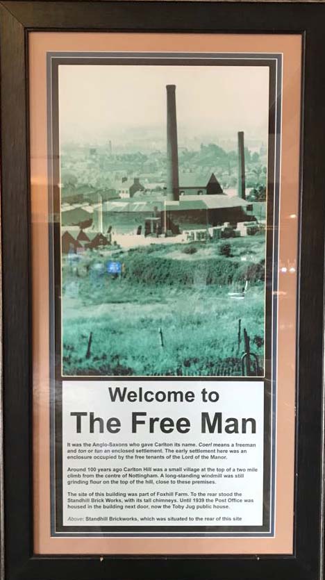
The text reads: It was the Anglo-Saxons who gave Carlton its name. Coerl means a freeman and ton or tun an enclosed settlement. The early settlement here was an enclosure occupied by the free tenants of the Lord of the Manor.
Around 100 years ago Carlton Hill was a small village at the top of a two mile climb from the centre of Nottingham. A long-standing windmill was still grinding flour on the top of the hill, close to these premises.
The site of this building was part of Foxhill Farm. To the rear stood the Standhill Brick Works, with its tall chimneys. Until 1939 the Post Office was housed in the building next door, now the Toby Jug public house.
Above: Standhill Brickworks, which was situated to the rear of this site.
Photographs, an illustration and text about the Co-op.
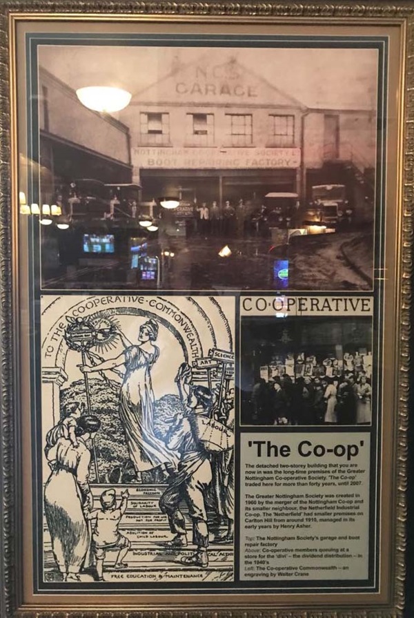
The text reads: The detached two-storey building that you are now in was the long-time premises of the Greater Nottingham Co-operative Society. The Co-op traded here for more than forty years, until 2007.
The Greater Nottingham Society was created in 1960 by the merger of the Nottingham Co-op and its smaller neighbour, the Netherfield Industrial Co-op. The ‘Netherfield’ had smaller premises on Carlton Hill from around 1910, managed in its early years by Henry Asher.
Top: The Nottingham Society’s garage and boot repair factory.
Above: Co-operative members queueing at a store for the ‘divi’ – the dividend distribution – in the 1940s.
Left: The Co-operative Commonwealth – an engraving by Walter Crane.
A photograph and text about Gedling Colliery.
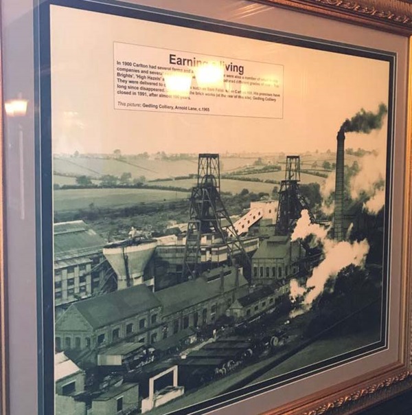
The text reads: In 1900 Carlton had several farms and a brick works. There were also a number of small textile companies and several coal mines in the area. The pits produced different grades of coal – Top Brights, High Hazels and Cobbles.
They were delivered to coal merchants such as Sam Felstead on Carlton Hill. His premises have long since disappeared. So too have the brick works (at the rear of this site). Gedling Colliery closed in 1991, after almost 100 years.
This picture: Gedling Colliery, Arnold Lane, c1965.
Text about the history of Carlton.
The text reads: During the second half of the nineteenth century Carlton began to develop as a residential area. In 1846 the Midland Railway opened a new line from Nottingham to Lincoln, with a station at Carlton.
Around that time the population was little more than 2,000. By 1881 it had doubled to 4,625. A Local Board was established the following year, responsible for drainage, sewerage and the collection of refuse. In 1894 its work was taken over by the urban District Council.
By 1901 the population of Carlton exceeded 1,000. A tram service was introduced just before the First World War. During the 1930s, Carlton expanded further. In 1974 it became part of Gedling Borough Council.
Illustrations and text about the Lovel family.
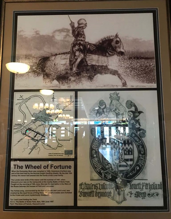
The text reads: When the Domesday Book was compiled in 1086, Carentune (Carlton) was part of the land held by the Norman knight Geoffrey Aiselin. By the late 15th century the manor had passed into the hands of the Lovel family.
The Lovels were lords of the manor until the summer of 1487, when Viscount Lovel was on the losing side at the nearby Battle of Stoke Field. Fought on the morning of 16th June, this was the last battle in the Wars of the Roses between the houses of York and Lancaster.
The Yorkist army, commanded by the Earl of Lincoln and Lord Lovel, was crushed by the royal forces of King Henry VII. Lovel’s estates were forfeited to the Crown and Lovel mysteriously disappeared.
Top: Lord Lovel fording the Trent
Above: The Battle of Stoke Field, 9am, 16th June 1487
Right: The Arms of Francis, Viscount Lovel
A photograph and text about Richard Beckinsale.
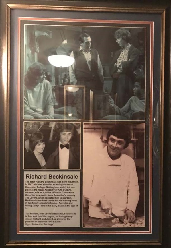
The text reads: The actor Richard Beckinsale was born in Carlton, in 1947. He later attended an acting course at Clarendon College, Nottingham, which led to a place at the Royal Academy of Arts (RADA). A cameo role as a police officer
A photograph and text about buildings in Carlton.
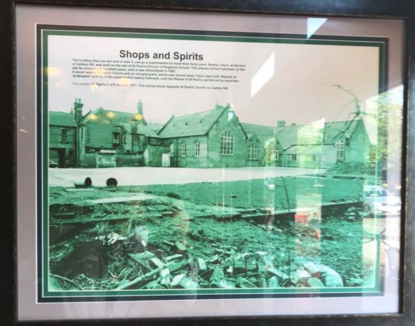
The text reads: The building that you are now in was in use as a supermarket for more than forty years. Nearby Tesco, at the foot of Carlton Hill, was built on the site of St Paul’s (Church of England) School. The primary school has been on the site for around one hundred years, until it was demolished in 1983.
It stood next to St Paul’s Church and an old graveyard, which was moved when Tesco was built. Reports of poltergeist activity in the supermarket bakery followed, until the Rector of St Paul’s carried out an exorcism.
This picture: St Paul’s C of E School, 1977. The school stood opposite St Paul’s Church on Carlton Hill.
External photograph of the building – main entrance.

If you have information on the history of this pub, then we’d like you to share it with us. Please e-mail all information to: pubhistories@jdwetherspoon.co.uk